
IMD issues red alerts for multiple districts in Haryana and orange alert in Punjab; storms and rain to impact wheat crops
By Anju Agnihotri Chaba
Several weather conditions across Punjab and Haryana, major wheat-growing states, are set to turn active over the next 24 hours, even as the India Meteorological Department (IMD) Monday issued a red alert for Haryana and orange and yellow alerts for Punjab and Chandigarh.
According to weather experts, widespread rain and storm activity are likely to bring both relief from rising temperatures and challenges due to agricultural and logistical disruptions.
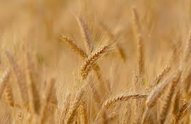
Experts warned that the forecast of strong winds and rainfall is not conducive to standing crops, particularly wheat, which is nearing the harvesting stage, as it can cause crop losses.
According to the latest advisory, thunderstorms accompanied by lightning, hail and gusty winds (40–50 kmph) are likely at isolated places in northern and central districts of Punjab, including Pathankot, Gurdaspur, Hoshiarpur, Nawanshahar, Rupnagar, and SAS Nagar (Mohali). In the rest of the state, thunderstorms with lightning and winds of 30–40 kmph are expected.
Light to moderate rainfall is likely at many places in Pathankot, Gurdaspur, Hoshiarpur, Nawanshahar, and Rupnagar. Several other districts, including Amritsar, Tarn Taran, Kapurthala, Jalandhar, Ludhiana, Bathinda, Barnala, Mansa, Sangrur, Patiala, and Mohali, are expected to receive rain at a few places, while isolated showers are likely in Ferozepur, Fazilka, Faridkot and Muktsar.
Gusty winds are expected to sweep across almost the entire state.
Chandigarh is also likely to witness thunderstorms accompanied by gusty winds and lightning, indicating a widespread weather system impacting the region.
Data suggests that minimum temperatures across Punjab will remain above normal, with the lowest recorded at around 15°C in Gurdaspur. Despite minor day-to-day variations, the overall trend indicates warmer-than-usual nights, even as incoming weather systems bring intermittent relief.
Red and orange alerts in Haryana
Meanwhile, parts of neighbouring Haryana were placed under red and orange alerts, with more intense weather activity expected.
IMD warned of moderate thunderstorms with winds reaching 40–60 kmph, lightning, and hail over several districts, including Firozpur Jhirka, Punahana, Hodal, Hathin, Nuh, Palwal, Taoru, Sohna, Gurugram, Rewari, Jhajjar, Bahadurgarh, and Faridabad. Similar thunderstorm activity is also expected in Mahendragarh, Narnaul, Charkhi Dadri, and adjoining areas.
Additionally, light rainfall is likely across parts of Hisar, Fatehabad, Karnal, Jind, Kaithal, Ambala, Panchkula, and Yamunanagar.
Minimum temperatures in Haryana are also above normal by over 3°C in many areas, with the lowest recorded around 18°C in Narnaul and Bhiwani.
The expected weather conditions—particularly strong winds and hail—may impact standing crops, especially wheat nearing harvest in both Punjab and Haryana.
Farmers have been advised to take necessary precautions, while residents are urged to avoid open areas during thunderstorms and secure loose structures.
“At this crucial phase, the crop requires dry weather conditions rather than excess moisture. High-velocity winds pose a serious threat by causing lodging, which can cause the crop to fall flat on the ground. This not only makes harvesting difficult but also increases the risk of grain discolouration and quality deterioration. Moreover, rainfall close to harvest can raise moisture levels in the grain, affecting its market value and potentially delaying procurement operations,” said farmer Palwinder Singh of Jalandhar.
This article has been republished from The Indian Express.